Catálogo de Metadados da ANA
Global Evapotranspiration Datasets Assessment Using Water Balance in South America
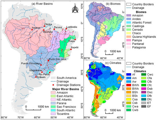
Evapotranspiration (ET) connects the land to the atmosphere, linking water, energy, and carbon cycles. ET is an essential climate variable with a fundamental importance, and accurate assessments of the spatiotemporal trends and variability in ET are needed from regional to continental scales. This study compared eight global actual ET datasets (ETgl) and the average actual ET ensemble (ETens) based on remote sensing, climate reanalysis, land-surface, and biophysical models to ET computed from basin-scale water balance (ETwb) in South America on monthly time scale. The 50 small-to-large basins covered major rivers and different biomes and climate types. We also examined the magnitude, seasonality, and interannual variability of ET, comparing ETgl and ETens with ETwb. Global ET datasets were evaluated between 2003 and 2014 from the following datasets: Breathing Earth System Simulator (BESS), ECMWF Reanalysis 5 (ERA5), Global Land Data Assimilation System (GLDAS), Global Land Evaporation Amsterdam Model (GLEAM), MOD16, Penman–Monteith–Leuning (PML), Operational Simplified Surface Energy Balance (SSEBop) and Terra Climate. By using ETwb as a basis for comparison, correlation coefficients ranged from 0.45 (SSEBop) to 0.60 (ETens), and RMSE ranged from 35.6 (ETens) to 40.5 mm·month−1 (MOD16). Overall, ETgl estimates ranged from 0 to 150 mm·month−1 in most basins in South America, while ETwb estimates showed maximum rates up to 250 mm·month−1. ETgl varied by hydroclimatic regions: (i) basins located in humid climates with low seasonality in precipitation, including the Amazon, Uruguay, and South Atlantic basins, yielded weak correlation coefficients between monthly ETgl and ETwb, and (ii) tropical and semiarid basins (areas where precipitation demonstrates a strong seasonality, as in the São Francisco, Northeast Atlantic, Paraná/Paraguay, and Tocantins basins) yielded moderate-to-strong correlation coefficients. An assessment of the interannual variability demonstrated a disagreement between ETgl and ETwb in the humid tropics (in the Amazon), with ETgl showing a wide range of interannual variability. However, in tropical, subtropical, and semiarid climates, including the Tocantins, São Francisco, Paraná, Paraguay, Uruguay, and Atlantic basins (Northeast, East, and South), we found a stronger agreement between ETgl and ETwb for interannual variability. Assessing ET datasets enables the understanding of land–atmosphere exchanges in South America, to improvement of ET estimation and monitoring for water management.
Simples
- Data (Publicação)
- 2022-05-25T00:00:00
- Edição
-
Base de dados publicada em 2022
- Modo de apresentação
- Mapa digital
- Finalidade
-
Sistematizar dados referentes à delimitação de bacias hidrográficas do Brasil
- Status
- Concluído
61-2109-5330
- Freqüência de atualização e manutenção
- Quando necessário
- Palavras-chave
-
-
global evapotranspiration
-
basin water balance
-
Terra Climate
-
SSEBop
-
PML
-
MOD16
-
GLEAM
-
GLDAS
-
ERA5
-
BESS
-
- Palavras-chave
-
-
2022
-
- Lugar
-
-
Brasil
-
- Outras restrições
-
O acesso ao dado é livre.
- Tipo de representação espacial
- Vector
- Denominador
- 1000000
- Languagem
-
por
- Character set
- UTF8
))
- Informações complementares
-
Dados espaciais baseados nos trabalhos abaixo:
Ruhoff, A.; de Andrade, B.C.; Laipelt, L.; Fleischmann, A.S.; Siqueira, V.A.; Moreira, A.A.; Barbedo, R.; Cyganski, G.L.; Fernandez, G.M.R.; Brêda, J.P.L.F.; Paiva, R.C.D.d.; Meller, A.; Teixeira, A.d.A.; Araújo, A.A.; Fuckner, M.A.; Biggs, T. Global Evapotranspiration Datasets Assessment Using Water Balance in South America. Remote Sensing, 2022, 14, 2526. https://doi.org/10.3390/rs14112526
Moreira, A.A.; Ruhoff, A.; Roberti, D.R.; Souza, V.A.; Rocha, H.R.; Paiva, R.C.D.d. Assessment of terrestrial water balance using remote sensing data in South America. Journal of Hydrology, 2019, 575, 131-147. ttps://doi.org/10.1016/j.jhydrol.2019.05.021.
- Identificador de sistema de referência
- EPSG / 4326 / 7.4
- Forma de distribuição
-
-
(
)
-
(
)
- Recursos onLine
-
River Basin - riverBasins_withWB_sorted.zip(SHP)
(
WWW:DOWNLOAD-1.0-http--download
)
River Basin
- Recursos onLine
-
Discharge Stations - discharge_stations_wgs84.zip(SHP)
(
WWW:DOWNLOAD-1.0-http--download
)
Discharge Stations
- Recursos onLine
-
Stations Streamflow - StationsStreamflow_mm_month-1.csv(CSV)
(
WWW:DOWNLOAD-1.0-http--download
)
Stations Streamflow
- Recursos onLine
-
Global Evapotranspiration Datasets Assessment Using Water Balance in South America (remotesensing-14-02526.pdf)
(
WWW:DOWNLOAD-1.0-http--download
)
Global Evapotranspiration Datasets Assessment Using Water Balance in South America
- Nível hierárquico
- Conjunto de dados
- Identificador do ficheiro
- ebcdf49c-706e-421f-aa70-bf866a0ab94e XML
- Languagem
-
por
- Character set
- UTF8
- Date stamp
- 2022-05-25T15:45:13
- Nome padrão dos metadados
-
ISO 19115:2003/19139
- Versão padrão dos metadados
-
1.0
61-2109-5330
Visões gerais
Extensão espacial
Providenciado por